
Reality Capture- 3D Models & Scans
Transforming Data into Insights
At MorLo Aerial Imaging, we specialize in reality capture- 3D model & laser scan services that generate accurate and comprehensive data for a variety of applications.
Our cutting-edge technology provides detailed information that empowers businesses to make informed decisions and enhance their operations.
Precision and Detail
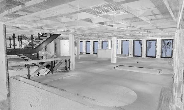
Our reality capture methods use advanced drone technology and ground-based laser scanning techniques, including LiDAR and visual documentation. This allows us to create high-resolution 3D models, maps, and digital twin representations of assets, ensuring you have the precise data needed for effective planning, analysis, and decision-making.
Deliverables Specific to your Industry
We specialize in solutions for many industries, ranging from architecture and engineering to real estate and Insurance. Our technology will provide your team with the data and deliverables it requires.
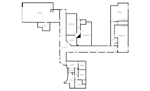
- Scan to CAD
- Technical Assets (.OBJ, .XYZ, etc.)
- Scan to BIM
- 3D BIM Modeling
- As-Built Documentation
- As-Built Models/Drawings
- 3D Digital Twin
- Sync with Procore and Autodesk
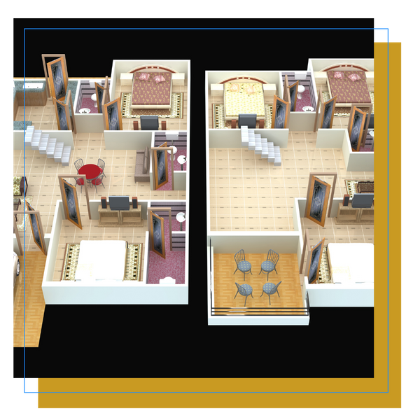
- Schematic Floor Plans
- Much more
3D Models & Scans For Any Industry
Capture Reality With A Digital Twin:See, Explore, Measure, Catalog, More.
AEC (Architecture, Engineering, Construction):
Perfect for design, As-Builts, and progress monitoring.
Provide true-to-life visualizations and renderings.
Establish baselines, monitor progress, retain as-built data for future reference.
Receive technical assets (.OBJ, .XYZ, etc.) to use with your CAD and modeling software such as Autodesk, Revit, Xactimate, and others.
99% accuracy.
Perform final inspections remotely and share with your team.
Show project progress to clients and stakeholders with a realistic interactive model before, during, and after completion.
Real Estate
Provide clients with an interactive 3D viewing experience.
Easily showcase your property in 360 degrees with a 3D digital twin.
Insurance and Restoration
Leverage rich and immersive 3D models for your documentation.
Xactimate-compatible 3D as-built model of any property.
A complete and accurate as-built sketch of your property is ready to upload into your Xactimate account within 48hrs.
Property and Asset Management
Improve inspection effectiveness
Eliminate ambiguity and minimize miscommunication with a digital twin.
3D models give real context to your assets and inspections.
Contact us today for your 3D model of your property.
Personalized Virtual Tours and Scans
Ideal for Real Estate and Virtual Retail Presence:
Virtual Retail Virtual Tour:
Engage with your customers, rain or shine!
Provide options for virtual tours and visits.
Promote new products.
Announce and display new exhibits or store layouts.
Embed your virtual tour into your website.
Hosting options available.
Real Estate Virtual Tour:
Showcase your listings and reach more buyers without the need to visit in person.
Virtual tours offer walkthroughs that are easy and intuitive to navigate.
Easily share with your clients via link to your virtual tour.
Have access to accurate schematic floor plans of your property.
Why Use Our Reality Capture Service
MorLo Aerial Imaging is dedicated to delivering exceptional service and quality. Our experienced team leverages the latest technology to ensure that our solutions are tailored to your specific needs. We prioritize collaboration with our clients to understand their unique objectives, providing customized insights that drive success.
Get Started Today!
Unlock the power of data with our reality capture services.